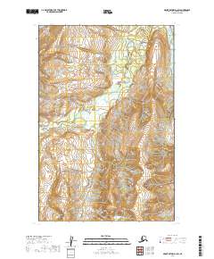
2019 Map of Mount Katmai D-1 SW
USGS Topo · Published 2019About this map
Katmai National Park encompasses the vast majority of this 2019 survey, protecting a wild landscape of steep ridgelines and glacial valleys. The terrain is defined by the northward flow of the Kamishak River, which is joined by the South Fork Kamishak River as they carve through the northeastern portion of the quadrangle. This area remains largely devoid of modern infrastructure or permanent settlements, preserving a wilderness character that reflects the federal land management priorities of the Kenai Peninsula Borough's western reaches. The map's contour lines illustrate the sharp elevation changes between the river basin and the high peaks, providing a clear view of the hydrological patterns within this protected coastal watershed.
Find a feature on this map
7 named features on this map. Tap any name to fly to it.
Don’t see what you’re looking for? This feature index may not catch every label — zoom into the map to look around manually.
Map Details
Editions of this 2019 Mount Katmai D-1 SW Map
This is the sole edition of this map. No revisions or reprints were ever made.
Other maps of this area

1948 · Mt Katmai
USGS Topo · 1:250,000

1951 · Mt Katmai
USGS Topo · 1:250,000

1951 · Mount Katmai D-1
USGS Topo · 1:63,360

1951 · Mount Katmai C-2
USGS Topo · 1:63,360

1951 · Mount Katmai D-2
USGS Topo · 1:63,360

1951 · Mount Katmai C-1
USGS Topo · 1:63,360
1953 · Mount Katmai C-2
USGS Topo · 1:63,360
1953 · Mount Katmai D-1
USGS Topo · 1:63,360

1964 · Mt. Katmai
USGS Topo · 1:250,000
2019 · Mount Katmai D-1 NE
USGS Topo · 1:25,000