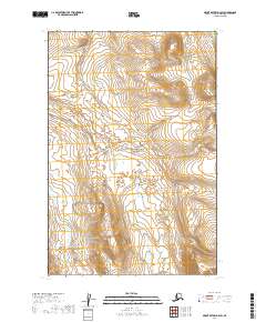
2019 Map of Mount Katmai D-4 SW
USGS Topo · Published 2019About this map
Katmai National Park encompasses the entirety of this 2019 landscape, dominated by a high-altitude wilderness defined by its dramatic topographic relief. The terrain rises sharply from the lower elevations in the west toward a series of prominent ridges and peaks that exceed 3,000 feet in the east and northeast. In the northeastern corner, Hammersly Lake sits tucked into the high ground, its shoreline tracing the contours of the surrounding peaks.
Find a feature on this map
6 named features on this map. Tap any name to fly to it.
Don’t see what you’re looking for? This feature index may not catch every label — zoom into the map to look around manually.
Map Details
Editions of this 2019 Mount Katmai D-4 SW Map
This is the sole edition of this map. No revisions or reprints were ever made.
Other maps of this area

1948 · Mt Katmai
USGS Topo · 1:250,000

1951 · Mt Katmai
USGS Topo · 1:250,000

1951 · Mount Katmai D-5
USGS Topo · 1:63,360

1951 · Mount Katmai C-5
USGS Topo · 1:63,360

1951 · Mount Katmai C-4
USGS Topo · 1:63,360

1951 · Mount Katmai D-4
USGS Topo · 1:63,360
1953 · Mount Katmai C-5
USGS Topo · 1:63,360

1964 · Mt. Katmai
USGS Topo · 1:250,000
2019 · Mount Katmai D-4 NW
USGS Topo · 1:25,000
2019 · Mount Katmai D-5 SE
USGS Topo · 1:25,000