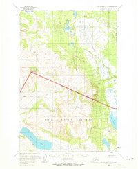
1951 Map of Mount Katmai D-6
USGS Topo · Published 1972About this map
Katmai National Monument defines the southern expanse of this Alaskan landscape, with the National Monument Boundary (Approximate) cutting diagonally across the center of the sheet. The terrain transitions from the low-lying wetlands and swamps of the north to the significant elevations surrounding Sugarloaf Mountain. Water dominates the hydrology of the quadrangle, notably where the Alagnak River flows in the northwest and American Creek drains toward the larger water bodies. The presence of Lake Coville and Idavain Lake in the southern portion suggests the remote glacial and volcanic character of the region as it was surveyed in the early 1950s. This survey, compiled from 1951 aerial photography, serves as a record of the park's early boundaries before its expansion into a national park and preserve.
Find a feature on this map
9 named features on this map. Tap any name to fly to it.
Don’t see what you’re looking for? This feature index may not catch every label — zoom into the map to look around manually.
Map Details
Editions of this 1951 Mount Katmai D-6 Map
2 editions found
Other maps of this area

1948 · Mt Katmai
USGS Topo · 1:250,000

1951 · Dillingham
USGS Topo · 1:250,000

1951 · Mt Katmai
USGS Topo · 1:250,000

1951 · Mount Katmai C-6
USGS Topo · 1:63,360

1951 · Naknek D-1
USGS Topo · 1:63,360

1951 · Mount Katmai D-5
USGS Topo · 1:63,360

1951 · Naknek C-1
USGS Topo · 1:63,360

1951 · Mount Katmai C-5
USGS Topo · 1:63,360

1951 · Mount Katmai D-6
USGS Topo · 1:63,360

1951 · Iliamna A-8
USGS Topo · 1:63,360