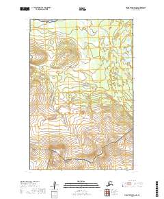
2019 Map of Mount Katmai D-6 NW
USGS Topo · Published 2019About this map
Katmai National Preserve and Katmai National Park dominate this 2019 survey, showcasing a transition between protected wilderness zones in the Lake and Peninsula Borough. The landscape is defined by its lack of human infrastructure, focusing instead on the complex hydrology of the Alagnak Wild River in the north and the rising elevations of Sugarloaf Mtn toward the southwest. This map illustrates the administrative boundaries of these federal lands at a high level of detail, marking the precise township and range lines such as t15s r40w that help georeference this remote area. The absence of roads or established settlements emphasizes the character of the Alaska Peninsula as a managed wilderness area where topographic features and natural watercourses remain the primary landmarks for navigation and land management.
Find a feature on this map
9 named features on this map. Tap any name to fly to it.
Don’t see what you’re looking for? This feature index may not catch every label — zoom into the map to look around manually.
Map Details
Editions of this 2019 Mount Katmai D-6 NW Map
This is the sole edition of this map. No revisions or reprints were ever made.
Other maps of this area

1948 · Mt Katmai
USGS Topo · 1:250,000

1951 · Dillingham
USGS Topo · 1:250,000

1951 · Mt Katmai
USGS Topo · 1:250,000

1951 · Naknek D-1
USGS Topo · 1:63,360

1951 · Mount Katmai D-6
USGS Topo · 1:63,360

1951 · Iliamna A-8
USGS Topo · 1:63,360

1951 · Dillingham A-1
USGS Topo · 1:63,360

1952 · Iliamna
USGS Topo · 1:250,000

1952 · Naknek
USGS Topo · 1:250,000
1952 · Iliamna A-8
USGS Topo · 1:63,360