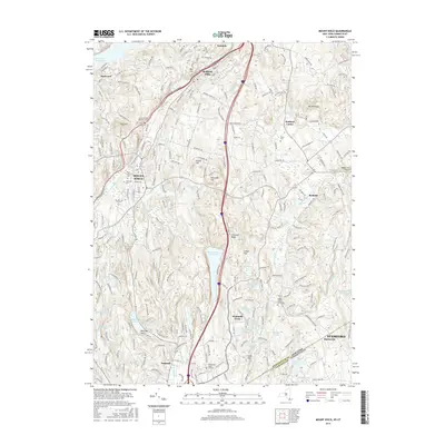
2016 Map of Mount Kisco
USGS Topo · Published 2016About this map
Bedford Hills and Mount Kisco anchor this survey of the suburbanizing borderlands between New York and Connecticut. The landscape is defined by its sophisticated water management systems, notably the New Croton Reservoir, Byram Lake Reservoir, and Wampus Lake Reservoir, which reflect the region's historical role in supporting metropolitan utility needs. Transportation networks are prominent, including the Metro-North Railroad and the Saw Mill River Pkwy, which facilitated the growth of these residential communities.
Find a feature on this map
55 named features on this map. Tap any name to fly to it.
Don’t see what you’re looking for? This feature index may not catch every label — zoom into the map to look around manually.
Map Details
Editions of this 2016 Mount Kisco Map
This is the sole edition of this map. No revisions or reprints were ever made.
Other maps of this area

1892 · Stamford
USGS Topo · 1:62,500

1892 · West Point
USGS Topo · 1:62,500

1892 · Carmel
USGS Topo · 1:62,500

1892 · Tarrytown
USGS Topo · 1:62,500

1893 · Carmel
USGS Topo · 1:62,500

1893 · Stamford
USGS Topo · 1:62,500

1893 · Tarrytown
USGS Topo · 1:62,500

1894 · West Point
USGS Topo · 1:62,500
1894 · Carmel
USGS Topo · 1:62,500
1899 · Stamford
USGS Topo · 1:62,500