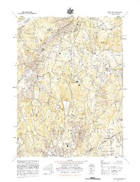
1982 Map of Mount Kisco
USGS Topo · Published 1982About this map
Byram Lake Reservoir and the New Croton Reservoir anchor this landscape of Northern Westchester, where the suburban transition meets old village centers in the early 1980s. The Mount Kisco town and village core shows a dense street grid compared to the winding roads of Bedford and the sprawling estates near Mt Aspetong. This era finds institutional land use prominently marked, from the expansive Bedford Hills Correctional Facility to the Montefiore Sanitarium and The Cenacle near Stanwood.
Find a feature on this map
78 named features on this map. Tap any name to fly to it.
Don’t see what you’re looking for? This feature index may not catch every label — zoom into the map to look around manually.
Map Details
Editions of this 1982 Mount Kisco Map
This is the sole edition of this map. No revisions or reprints were ever made.
Other maps of this area

1892 · Stamford
USGS Topo · 1:62,500

1892 · West Point
USGS Topo · 1:62,500

1892 · Carmel
USGS Topo · 1:62,500

1892 · Tarrytown
USGS Topo · 1:62,500

1893 · Carmel
USGS Topo · 1:62,500

1893 · Stamford
USGS Topo · 1:62,500

1893 · Tarrytown
USGS Topo · 1:62,500

1894 · West Point
USGS Topo · 1:62,500

1894 · Carmel
USGS Topo · 1:62,500

1899 · Stamford
USGS Topo · 1:62,500