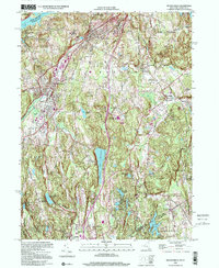
1998 Map of Mount Kisco
USGS Topo · Published 2001About this map
Mount Kisco serves as a primary hub of development in this Westchester County landscape, situated along the Saw Mill River Parkway. The map illustrates a region defined by its significant water infrastructure, from the southern edges of the New Croton Reservoir to the Byram Lake Reservoir and Wampus Lake Reservoir. The settlement pattern in Bedford and Bedford Hills reflects a mix of institutional and residential life, featuring sites like St Patricks Ch and the Rippowam-Cisqua Sch. To the south, the village of Banksville sits right on the border with Greenwich, Connecticut. Numerous country clubs and estates, such as Seven Springs Farm, indicate the area's mid-to-late 20th-century character as an established suburban and recreational corridor north of New York City.
Find a feature on this map
46 named features on this map. Tap any name to fly to it.
Don’t see what you’re looking for? This feature index may not catch every label — zoom into the map to look around manually.
Map Details
Editions of this 1998 Mount Kisco Map
This is the sole edition of this map. No revisions or reprints were ever made.
Other maps of this area

1892 · Stamford
USGS Topo · 1:62,500

1892 · West Point
USGS Topo · 1:62,500

1892 · Carmel
USGS Topo · 1:62,500

1892 · Tarrytown
USGS Topo · 1:62,500

1893 · Carmel
USGS Topo · 1:62,500

1893 · Stamford
USGS Topo · 1:62,500

1893 · Tarrytown
USGS Topo · 1:62,500

1894 · West Point
USGS Topo · 1:62,500

1894 · Carmel
USGS Topo · 1:62,500

1899 · Stamford
USGS Topo · 1:62,500