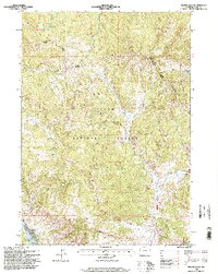
1996 Map of Mount Leidy
USGS Topo · Published 1998About this map
Mount Leidy stands as a central high point in this portion of the Teton National Forest, where the landscape is defined by the complex drainage systems of the Gros Ventre River and its numerous tributaries. The map details a backcountry environment where human presence is marked primarily by seasonal and utilitarian features, such as a Hunting Camp and a Landing Strip near the riverbanks. The terrain shifts from the prominent Lavender Hills and Red Hills in the south to the high-elevation Topping Lakes in the north.
Find a feature on this map
27 named features on this map. Tap any name to fly to it.
Don’t see what you’re looking for? This feature index may not catch every label — zoom into the map to look around manually.
Map Details
Editions of this 1996 Mount Leidy Map
This is the sole edition of this map. No revisions or reprints were ever made.
Other maps of this area

1899 · Grand Teton
USGS Topo · 1:125,000

1901 · Grand Teton
USGS Topo · 1:125,000

1902 · Mt Leidy
USGS Topo · 1:125,000

1955 · Driggs
USGS Topo · 1:250,000

1958 · Driggs
USGS Topo · 1:250,000

1962 · Driggs
USGS Topo · 1:250,000

1965 · Davis Hill
USGS Topo · 1:24,000

1965 · Green Mountain
USGS Topo · 1:24,000

1965 · Rosies Ridge
USGS Topo · 1:24,000

1965 · Mount Leidy
USGS Topo · 1:24,000