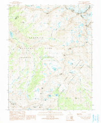
1990 Map of Mount Lyell
USGS Topo · Published 1990About this map
The high Sierra crest converges in this 1990 survey at the triple point of Mariposa, Madera, and Tuolumne counties. The landscape is dominated by the glacial remnants of the Cathedral Range and the Ritter Range, with Mount Lyell and Mount Maclure anchoring the northern boundary. These peaks feed the headwaters of the Lyell Fork and the Merced River, which cuts through the western portion of the Yosemite Wilderness. The map captures a high-altitude wilderness before contemporary glacial retreat, documenting the extent of the Lyell Glacier and Maclure Glacier alongside remote alpine basins like those containing Isberg Lakes and Sadler Lake. Significant trail crossings are identified at Isberg Pass and Post Peak Pass, which historically linked these drainage basins. South of the park boundary, the Ansel Adams Wilderness encompasses Mount Ansel Adams and the deep drainage of Bench Canyon.
Find a feature on this map
49 named features on this map. Tap any name to fly to it.
Don’t see what you’re looking for? This feature index may not catch every label — zoom into the map to look around manually.
Map Details
Editions of this 1990 Mount Lyell Map
This is the sole edition of this map. No revisions or reprints were ever made.
Other maps of this area

1901 · Mt. Lyell
USGS Topo · 1:125,000

1947 · Mariposa
USGS Topo · 1:250,000

1948 · Mariposa
USGS Topo · 1:250,000

1953 · Merced Peak
USGS Topo · 1:62,500

1953 · Mono Craters
USGS Topo · 1:62,500

1953 · Devils Postpile
USGS Topo · 1:62,500

1956 · Tuolumne Meadows
USGS Topo · 1:62,500

1957 · Mariposa
USGS Topo · 1:250,000

1963 · Mariposa
USGS Topo · 1:250,000
1976 · Yosemite Valley
USGS Topo · 1:100,000