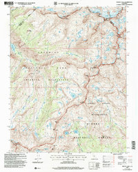
2004 Map of Mount Lyell
USGS Topo · Published 2007About this map
Mount Lyell and the surrounding high-altitude wilderness are depicted here in the early 2000s, where the boundaries of Yosemite National Park, Ansel Adams Wilderness, and Sierra National Forest converge. This survey captures a specific glaciated landscape prior to significant modern retreats, detailing both the Lyell Glacier and Maclure Glacier below their respective peaks. The high-country drainage system is remarkably clear, showing the headwaters of the Merced River and the Lyell Fork. This area is defined by its topographic extremes, including Triple Divide Peak and the Clark Range, which serve as critical hydrological junctions. Backcountry researchers can trace established paths through Isberg Pass and Post Peak Pass, which have historically connected these high-Sierra regions.
Find a feature on this map
49 named features on this map. Tap any name to fly to it.
Don’t see what you’re looking for? This feature index may not catch every label — zoom into the map to look around manually.
Map Details
Editions of this 2004 Mount Lyell Map
This is the sole edition of this map. No revisions or reprints were ever made.
Other maps of this area

1901 · Mt. Lyell
USGS Topo · 1:125,000

1947 · Mariposa
USGS Topo · 1:250,000

1948 · Mariposa
USGS Topo · 1:250,000

1953 · Merced Peak
USGS Topo · 1:62,500

1953 · Mono Craters
USGS Topo · 1:62,500

1953 · Devils Postpile
USGS Topo · 1:62,500

1956 · Tuolumne Meadows
USGS Topo · 1:62,500

1957 · Mariposa
USGS Topo · 1:250,000

1963 · Mariposa
USGS Topo · 1:250,000
1976 · Yosemite Valley
USGS Topo · 1:100,000