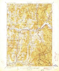
1927 Map of Mount Mansfield
USGS Topo · Published 1927About this map
The Lamoille River valley serves as the central corridor for this 1920s survey, where the St. Johnsbury and Lake Champlain Railroad meets the Central Vermont line. This era of mountain transit is well-preserved, featuring the Toll Road winding toward the peaks and the high-elevation Halfway House. The landscape is dotted with small-scale neighborhood infrastructure, including more than a dozen local schoolhouses such as the English Settlement School and the Buck Hollow School, reflecting a decentralized rural society before the consolidation of the mid-20th century. At Smugglers Notch, the terrain rises sharply from the valley floors of Cambridge and Underhill, while industrial relics like Moises Mill suggest a working landscape deeply tied to the river systems and mountain gaps.
Find a feature on this map
118 named features on this map. Tap any name to fly to it.
Don’t see what you’re looking for? This feature index may not catch every label — zoom into the map to look around manually.
Map Details
Editions of this 1927 Mount Mansfield Map
5 editions found

Other maps of this area

1906 · Burlington
USGS Topo · 1:62,500

1913 · Milton
USGS Topo · 1:48,000

1914 · St. Albans
USGS Topo · 1:48,000

1915 · Milton
USGS Topo · 1:62,500

1916 · St. Albans
USGS Topo · 1:62,500

1919 · Burlington
USGS Topo · 1:62,500

1919 · Montgomery
USGS Topo · 1:62,500

1919 · Montpelier
USGS Topo · 1:62,500

1920 · Franklin Pond
USGS Topo · 1:62,500

1920 · Montgomery
USGS Topo · 1:62,500