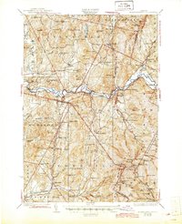
1927 Map of Mount Mansfield
USGS Topo · Published 1945About this map
Lamoille River valley life centers on the rail intersections and small farming hamlets in this mid-1920s survey of the Green Mountains. The landscape is defined by the Central Vermont RR and the St Johnsbury & Lake Champlain RR, which meet at Cambridge Junction. These lines supported the local dairy and timber economies, connecting places like Jeffersonville and East Fletcher Sta to wider markets.
Find a feature on this map
125 named features on this map. Tap any name to fly to it.
Don’t see what you’re looking for? This feature index may not catch every label — zoom into the map to look around manually.
Map Details
Editions of this 1927 Mount Mansfield Map
5 editions found

Other maps of this area

1906 · Burlington
USGS Topo · 1:62,500

1913 · Milton
USGS Topo · 1:48,000

1914 · St. Albans
USGS Topo · 1:48,000

1915 · Milton
USGS Topo · 1:62,500

1916 · St. Albans
USGS Topo · 1:62,500

1919 · Burlington
USGS Topo · 1:62,500

1919 · Montgomery
USGS Topo · 1:62,500

1919 · Montpelier
USGS Topo · 1:62,500

1920 · Franklin Pond
USGS Topo · 1:62,500

1920 · Montgomery
USGS Topo · 1:62,500