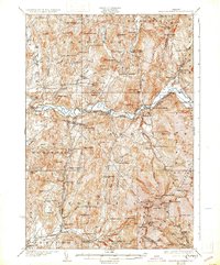
1927 Map of Mount Mansfield
USGS Topo · Published 1931About this map
Smugglers Notch and the high ridges of the Green Mountains dominate this mid-1920s landscape, where the Lamoille River carves a deep valley through the northern Vermont hills. The region’s economic life is visible in the network of the Central Vermont Ry, which services hubs like Cambridge Junction and East Fletcher. This era shows a landscape densely populated with small local institutions, particularly specialized rural schools such as the Irish Settlement School, Osgood Hill School, and Number Eleven School, reflecting a period before the consolidation of mountain townships. Along the riverbanks and mountain streams, industrial sites like the Morse Mill and the power at Fairfax Falls indicate the late-stage reliance on water power and timber that characterized the Lamoille Valley. The map also records higher-elevation landmarks like the Lake of the Clouds and the winding Toll Road climbing toward the summit.
Find a feature on this map
117 named features on this map. Tap any name to fly to it.
Don’t see what you’re looking for? This feature index may not catch every label — zoom into the map to look around manually.
Map Details
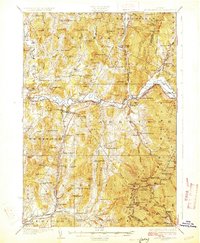
Editions of this 1927 Mount Mansfield Map
5 editions found

Other maps of this area

1906 · Burlington
USGS Topo · 1:62,500

1913 · Milton
USGS Topo · 1:48,000

1914 · St. Albans
USGS Topo · 1:48,000

1915 · Milton
USGS Topo · 1:62,500

1916 · St. Albans
USGS Topo · 1:62,500

1919 · Burlington
USGS Topo · 1:62,500

1919 · Montgomery
USGS Topo · 1:62,500

1919 · Montpelier
USGS Topo · 1:62,500

1920 · Franklin Pond
USGS Topo · 1:62,500

1920 · Montgomery
USGS Topo · 1:62,500