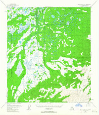
1954 Map of Mount McKinley D-2
USGS Topo · Published 1963About this map
Kantishna Hills dominate the southeastern quadrant of this interior Alaska landscape, providing a sharp contrast to the extensive marshlands and braided waterways to the north and west. In the mid-1950s, this area centered around the isolated settlement of Diamond, a focal point for activity along the Bearpaw River. The map captures a moment when travel in the bush relied heavily on seasonal infrastructure, as evidenced by the Sled Road cutting across the northern reaches and the Crooked Creek Landing Strip tucked near the hills. Drainage systems like Moose Creek and Flume Creek feed into the larger river basins, highlighting the complex hydrology of the region. The presence of VABM Diamond suggests a landscape surveyed for both navigation and resource potential, where the Kantishna River served as a primary artery through the remote subarctic terrain.
Find a feature on this map
12 named features on this map. Tap any name to fly to it.
Don’t see what you’re looking for? This feature index may not catch every label — zoom into the map to look around manually.
Map Details
Editions of this 1954 Mount McKinley D-2 Map
2 editions found

Other maps of this area

1948 · Kantishna River
USGS Topo · 1:250,000

1951 · Kantishna River
USGS Topo · 1:250,000

1951 · Mount McKinley D-1
USGS Topo · 1:63,360

1952 · Mount McKinley
USGS Topo · 1:250,000

1952 · Kantishna River A-3
USGS Topo · 1:63,360

1952 · Kantishna River A-1
USGS Topo · 1:63,360

1952 · Kantishna River
USGS Topo · 1:250,000

1952 · Mount McKinley C-3
USGS Topo · 1:63,360

1952 · Kantishna River A-2
USGS Topo · 1:63,360

1952 · Mount McKinley C-1
USGS Topo · 1:63,360