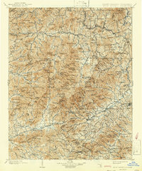
1902 Map of Mount Mitchell
USGS Topo · Published 1942About this map
Marion serves as a primary hub in the east as the Southern Railway winds through the river valleys of western North Carolina. Surveyed at the close of the 19th century, this terrain is defined by the high peaks of the Pisgah National Forest, including the landmark Big Tom Wilson. The map documents a landscape of isolated mountain settlements like Barnardsville and Burnsville connected by early valley roads and the rail corridor. Economic life in the region is marked by the Mica Mine near Mica and the industrial activity around Sprucepine. Significant water systems, including the Cane River and the headwaters of the Catawba River, dictate the placement of communities such as Swannanoa and Black Mountain. These features reflect an era when the railroad was the essential lifeline for commerce and travel through the Blue Ridge.
Find a feature on this map
179 named features on this map. Tap any name to fly to it.
Don’t see what you’re looking for? This feature index may not catch every label — zoom into the map to look around manually.
Map Details
Editions of this 1902 Mount Mitchell Map
3 editions found

Other maps of this area

1891 · Roan Mountain
USGS Topo · 1:125,000

1892 · Greeneville
USGS Topo · 1:125,000

1893 · Cranberry
USGS Topo · 1:125,000

1894 · Asheville
USGS Topo · 1:125,000

1894 · Roan Mountain
USGS Topo · 1:125,000

1895 · Cranberry
USGS Topo · 1:125,000

1896 · Greeneville
USGS Topo · 1:125,000

1899 · Cranberry
USGS Topo · 1:125,000

1900 · Mount Mitchell
USGS Topo · 1:125,000

1901 · Asheville
USGS Topo · 1:125,000