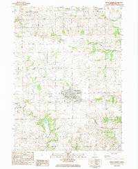
1983 Map of Mount Morris
USGS Topo · Published 1984About this map
Mount Morris sits at the center of this Ogle County landscape, serving as a hub for a network of country roads like Adeline Road and Mt Morris Road that connect the surrounding farmsteads. The terrain is defined by the winding course of the Leaf River to the north and Pine Creek to the south, with the Oregon Trail cutting through the southeastern corner. This survey documents the intersection of rail and aviation in the early 1980s, featuring the Burlington Northern line and small local airfields such as Nick Lung Airport and Barnett Memorial Airport. Genealogists will find a high density of rural burial sites, including Oak Wood Cem, Plainview Cem, and Cedar Hill Cem, which preserve the names of early family settlements across the Maryland and Mount Morris townships.
Find a feature on this map
49 named features on this map. Tap any name to fly to it.
Don’t see what you’re looking for? This feature index may not catch every label — zoom into the map to look around manually.
Map Details
Editions of this 1983 Mount Morris Map
This is the sole edition of this map. No revisions or reprints were ever made.
Other maps of this area

1918 · Dixon
USGS Topo · 1:62,500

1922 · Oregon
USGS Topo · 1:62,500

1924 · Oregon
USGS Topo · 1:62,500

1930 · Woodsung
USGS Topo · 1:48,000

1942 · Forreston
USGS Topo · 1:62,500

1945 · Forreston
USGS Topo · 1:62,500

1946 · Sterling
USGS Topo · 1:62,500

1948 · Sterling
USGS Topo · 1:62,500

1950 · Dixon
USGS Topo · 1:62,500

1954 · Rockford
USGS Topo · 1:250,000
Featured Places
- Mount Morris, IL
- Leaf River, IL
- Pine Creek Township, IL
- Oregon - Nashua Township, IL
- Maryland Township, IL