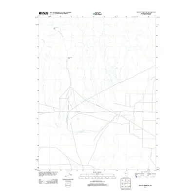
2011 Map of Mount Moses SE
USGS Topo · Published 2011About this map
Cottonwood Ranch sits at the heart of this high-desert landscape in Lander County, marking a pocket of settlement within a network of seasonal drainages. The terrain is defined by the broad expanse of Antelope Vly and the depression of Cottonwood Basin to the north. Water management in this arid environment is evidenced by features like Brides Wls, while the primary transport corridors follow the natural topography, notably Antelope Valley Rd. The hydrological system is dominated by the branching paths of Cottonwood Creek and Cain Creek, which carve through the basin floor. This 2011 survey captures the area's transition between working ranch lands and the open desert, where life and travel are dictated by the scarce water sources and the reach of local roads.
Find a feature on this map
7 named features on this map. Tap any name to fly to it.
Don’t see what you’re looking for? This feature index may not catch every label — zoom into the map to look around manually.
Map Details
Editions of this 2011 Mount Moses SE Map
This is the sole edition of this map. No revisions or reprints were ever made.
Other maps of this area

1932 · Sonoma Range
USGS Topo · 1:250,000

1939 · Sonoma Range
USGS Topo · 1:250,000

1955 · Millett
USGS Topo · 1:250,000

1955 · Winnemucca
USGS Topo · 1:250,000

1958 · Winnemucca
USGS Topo · 1:250,000

1959 · Millett
USGS Topo · 1:250,000

1961 · The Cedars
USGS Topo · 1:62,500

1961 · Mt. Moses
USGS Topo · 1:62,500

1962 · Winnemucca
USGS Topo · 1:250,000
1969 · Manhattan Mtn NW
USGS Topo · 1:24,000