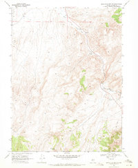
1969 Map of Manhattan Mtn NW
USGS Topo · Published 1971About this map
The Reese River carves a path through this central Nevada landscape, tracing a route that historically dictated movement through the high desert. By the late 1960s, the terrain was marked by the remnants of earlier industrial infrastructure, most notably the Old Railroad Grade that parallels the river's eastern banks. This corridor shows a history of transit and resource extraction, with scattered prospects and gravel pits indicating mineral exploration in the surrounding hills. Water remains the primary constraint and focal point of the area, anchored by locations like Willow Creek Spring and the Gaging Station used to monitor the river's flow. While much of the land is accessed only by Jeep Trail, the presence of Bobtown Well suggests the localized infrastructure required to support life and livestock in this arid Basin and Range environment.
Find a feature on this map
10 named features on this map. Tap any name to fly to it.
Don’t see what you’re looking for? This feature index may not catch every label — zoom into the map to look around manually.
Map Details
Editions of this 1969 Manhattan Mtn NW Map
2 editions found
Other maps of this area

1932 · Sonoma Range
USGS Topo · 1:250,000

1939 · Sonoma Range
USGS Topo · 1:250,000

1955 · Millett
USGS Topo · 1:250,000

1955 · Winnemucca
USGS Topo · 1:250,000

1958 · Winnemucca
USGS Topo · 1:250,000

1959 · Millett
USGS Topo · 1:250,000

1961 · The Cedars
USGS Topo · 1:62,500

1961 · Mt. Moses
USGS Topo · 1:62,500

1962 · Winnemucca
USGS Topo · 1:250,000

1969 · Manhattan Mtn
USGS Topo · 1:24,000