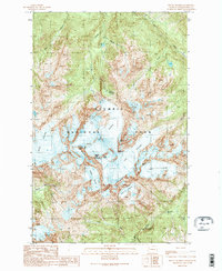
1990 Map of Mount Olympus
USGS Topo · Published 1990About this map
Mount Olympus dominates this high-altitude survey, serving as the central massif for an extensive network of active ice fields. The map documents the convergence of several major glaciers, including the massive Blue Glacier and the Hoh Glacier, which feed the headwaters of the Hoh River. Remote alpine infrastructure is noted at Glacier Meadows, where a Shelter and established trails support mountaineers and researchers. The drainage patterns are clearly defined, showing how the South Fork Hoh River and the Queets River originate from these glacial melts. This 1990 provisional edition, based on late-1980s data, provides a detailed record of the ice extent and topographical relief of the East Peak and Middle Peak before modern shifts in alpine conditions. It captures the rugged character of the Olympic National Park backcountry, from the sheer heights of Snow Dome to the lower elevation Service Falls.
Find a feature on this map
27 named features on this map. Tap any name to fly to it.
Don’t see what you’re looking for? This feature index may not catch every label — zoom into the map to look around manually.
Map Details
Editions of this 1990 Mount Olympus Map
2 editions found
Other maps of this area

1935 · Mount Olympus
USGS Topo · 1:62,500

1939 · Mount Tom
USGS Topo · 1:62,500

1942 · Mount Olympus
USGS Topo · 1:62,500

1947 · Mt Christie
USGS Topo · 1:62,500

1950 · Mt Christie
USGS Topo · 1:62,500

1950 · Hurricane Hill
USGS Topo · 1:24,000
1950 · Bogachiel Peak
USGS Topo · 1:24,000
1950 · Mount Carrie
USGS Topo · 1:24,000

1956 · Mount Olympus
USGS Topo · 1:62,500

1956 · Kloochman Rock
USGS Topo · 1:62,500