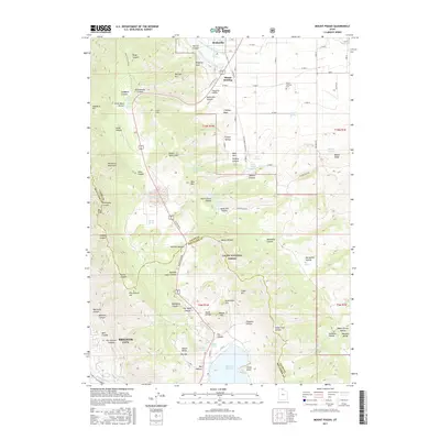
2017 Map of Mount Pisgah
USGS Topo · Published 2017About this map
Wellsville and Mount Sterling anchor the northern reaches of this 2017 survey, where the agricultural landscape meets the steep ascent of the Wellsville Mountains. The complex water management of the Cache Valley is evident in the paths of the Wellsville-Mendon Lower-Canal and the Wellsville-Mendon Upper-Canal, which trace the contours above the valley floor to support local farming. To the south, the terrain climbs toward Sardine Summit, a critical transit point on US Hwy 89 91 connecting the valley to Brigham City. Within the Cache National Forest, the map reveals a network of canyons and family-named landmarks like McMurdie Hollow and Babbit Shanty Hill. The presence of the Mount Sterling Cem and numerous named springs, such as Murray Spring and Sardine Spring, provide specific points of interest for those documenting the history of settlement and resource use in the northern Wasatch Range.
Find a feature on this map
108 named features on this map. Tap any name to fly to it.
Don’t see what you’re looking for? This feature index may not catch every label — zoom into the map to look around manually.
Map Details
Editions of this 2017 Mount Pisgah Map
This is the sole edition of this map. No revisions or reprints were ever made.
Other maps of this area

1914 · Logan
USGS Topo · 1:125,000

1916 · Logan
USGS Topo · 1:125,000

1954 · Ogden
USGS Topo · 1:250,000

1954 · Brigham City
USGS Topo · 1:250,000

1955 · Paradise
USGS Topo · 1:24,000

1955 · Mantua
USGS Topo · 1:24,000

1955 · James Peak
USGS Topo · 1:24,000

1955 · Willard
USGS Topo · 1:24,000

1955 · Mount Pisgah
USGS Topo · 1:24,000

1955 · Brigham City
USGS Topo · 1:24,000