1955 Map of Brigham City
USGS Topo · Published 1957About this map
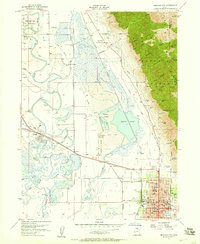
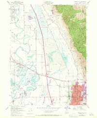
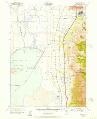
Brigham City serves as the focal point of this mid-1950s survey, showing a structured grid of schools like Box Elder High Sch and Lincoln Sch alongside the Courthouse and Armory. The landscape transitions sharply from the developed streets of the county seat to the rugged slopes of the Cache National Forest, where numerous drainages like Cataract Canyon and Antimony Canyon carve into the mountainside. To the west, the Bear River meanders through a complex network of wetlands and sloughs, including The Horseshoe and Black Slough, while the sprawling Salt Flat and North Lake dominate the central basin. This era captures the vital transportation corridor of the Union Pacific railroad as it connects Corinne and Honeyville, bypassing the industrial Cement Ponds and the Brigham City Airport. Insight into local heritage is found at the Historical Monument near Calls Fort, marking the early pioneer presence in this diverse valley environment.
Find a feature on this map
77 named features on this map. Tap any name to fly to it.
Don’t see what you’re looking for? This feature index may not catch every label — zoom into the map to look around manually.
Map Details
Editions of this 1955 Brigham City Map
2 editions found
Other maps of this area

1914 · Logan
USGS Topo · 1:125,000

1916 · Logan
USGS Topo · 1:125,000

1954 · Whistler Canal
USGS Topo · 1:24,000

1954 · Ogden
USGS Topo · 1:250,000

1954 · Brigham City
USGS Topo · 1:250,000
1955 · Mantua
USGS Topo · 1:24,000
1955 · Bear River City
USGS Topo · 1:24,000
1955 · Willard
USGS Topo · 1:24,000
1955 · Mount Pisgah
USGS Topo · 1:24,000

1958 · Ogden
USGS Topo · 1:250,000