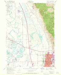
1955 Map of Brigham City
USGS Topo · Published 1971About this map
The Wellsville Mountains dominate the eastern landscape of this mid-century survey, casting long shadows over the developed corridors of Brigham City. The map documents a complex hydrological system where the Bear River and Malad River wind through extensive marshlands and Sloughs, eventually feeding toward the Great Salt Lake. This geography is defined by its industrial and transit infrastructure, featuring the prominent Union Pacific Railroad line and specialized areas like the Cement Ponds and the Brigham City Airport.
Find a feature on this map
56 named features on this map. Tap any name to fly to it.
Don’t see what you’re looking for? This feature index may not catch every label — zoom into the map to look around manually.
Map Details
Editions of this 1955 Brigham City Map
2 editions found
Other maps of this area

1914 · Logan
USGS Topo · 1:125,000

1916 · Logan
USGS Topo · 1:125,000

1954 · Whistler Canal
USGS Topo · 1:24,000

1954 · Ogden
USGS Topo · 1:250,000

1954 · Brigham City
USGS Topo · 1:250,000

1955 · Mantua
USGS Topo · 1:24,000

1955 · Bear River City
USGS Topo · 1:24,000

1955 · Willard
USGS Topo · 1:24,000

1955 · Mount Pisgah
USGS Topo · 1:24,000

1955 · Brigham City
USGS Topo · 1:24,000