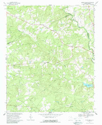
1967 Map of Mount Pisgah
USGS Topo · Published 1988About this map
Lynches River carves the northeast boundary of this landscape along the border of Kershaw and Chesterfield counties, anchoring a rural region defined by small agricultural settlements and a network of country churches. Small-scale resource extraction is evident through numerous Claypit and Sandpit sites scattered across the terrain, while the local economy is further represented by water-dependent sites such as Raley Millpond and Minton Mill. The settlement pattern centers on community nodes like Mt Pisgah and Midway Crossroads, with a high density of religious and burial sites including Crossroad Ch, Sandy Grove Ch, and Stroud Cem. In the western portion, a Lookout Tower stands near Buffalo Ch, overlooking the drainages of Buffalo Creek and Little Buffalo Creek as they move through this part of the South Carolina sandhills during the late 1960s.
Find a feature on this map
33 named features on this map. Tap any name to fly to it.
Don’t see what you’re looking for? This feature index may not catch every label — zoom into the map to look around manually.
Map Details
Editions of this 1967 Mount Pisgah Map
2 editions found
Other maps of this area

1935 · Camden
USGS Topo · 1:48,000

1938 · Camden
USGS Topo · 1:62,500

1941 · Spartanburg
USGS Topo · 1:250,000

1942 · Camden
USGS Topo · 1:125,000

1953 · Spartanburg
USGS Topo · 1:250,000

1960 · Spartanburg
USGS Topo · 1:250,000

1963 · Spartanburg
USGS Topo · 1:250,000

1964 · Spartanburg
USGS Topo · 1:250,000

1967 · Angelus
USGS Topo · 1:24,000

1967 · Mount Pisgah
USGS Topo · 1:24,000