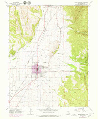
1967 Map of Mount Pleasant
USGS Topo · Published 1979About this map
Mount Pleasant serves as the central hub of this Sanpete Valley study, shown during a period of urban expansion reflected in purple revision tints. The town's grid is anchored by the Denver and Rio Grande Western railroad, which runs north through the valley toward Fairview. The landscape is defined by the transition from the irrigated fields of the valley floor, fed by the Mount Pleasant Canal and Moroni Canal, to the rising elevations of the Cedar Hills and the Round Hills. Rural landmarks like the Drive-in Theater on the north edge of town and the Mount Pleasant Airport to the southwest illustrate the community's mid-century development. In the southern reaches, the curious label Last Chance sits along Cedar Creek, while numerous Gravel Pits and a Radio Facility dot the periphery of the residential center.
Find a feature on this map
48 named features on this map. Tap any name to fly to it.
Don’t see what you’re looking for? This feature index may not catch every label — zoom into the map to look around manually.
Map Details
Editions of this 1967 Mount Pleasant Map
2 editions found
Other maps of this area

1885 · Manti
USGS Topo · 1:250,000

1895 · Manti
USGS Topo · 1:250,000

1951 · Moroni
USGS Topo · 1:62,500

1956 · Price
USGS Topo · 1:250,000

1960 · Price
USGS Topo · 1:250,000

1962 · Price
USGS Topo · 1:250,000

1965 · Huntington Reservoir
USGS Topo · 1:24,000

1965 · Fairview Lakes
USGS Topo · 1:24,000

1966 · Spring City
USGS Topo · 1:24,000

1966 · Chester
USGS Topo · 1:24,000