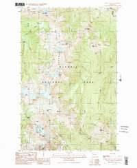
1990 Map of Mount Queets
USGS Topo · Published 1990About this map
Olympic National Park defines this high-elevation landscape, where the Bailey Range forms a spine of peaks including Stephen Peak, Mount Ferry, and Mount Scott. The terrain is shaped by the headwaters of several major glacial drainages, most notably the Queets River and Goldie River, which flow from the slopes of Mount Queets. Notable for backcountry researchers and climbers, the map identifies critical high-country transit points such as Dodwell-Rixon Pass and Bear Pass. A permanent human presence is marked by the Dodger Point Lookout in the northeastern corner, perched near the boundary of Jefferson and Clallam counties. The presence of the Queets Glacier and the Elwha Basin underscores the extreme relief and hydrological significance of this wilderness area during the late twentieth century.
Find a feature on this map
28 named features on this map. Tap any name to fly to it.
Don’t see what you’re looking for? This feature index may not catch every label — zoom into the map to look around manually.
Map Details
Editions of this 1990 Mount Queets Map
2 editions found
Other maps of this area

1935 · Mount Olympus
USGS Topo · 1:62,500

1938 · Mt Constance
USGS Topo · 1:125,000

1942 · Mount Olympus
USGS Topo · 1:62,500

1944 · Mt. Angeles
USGS Topo · 1:62,500

1946 · Mt. Angeles
USGS Topo · 1:62,500

1947 · Mt. Steel
USGS Topo · 1:62,500

1947 · Mt Christie
USGS Topo · 1:62,500

1950 · Mt Christie
USGS Topo · 1:62,500

1950 · Mt. Steel
USGS Topo · 1:62,500

1950 · Hurricane Hill
USGS Topo · 1:24,000