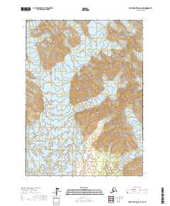
2017 Map of Mount Saint Elias A-6 SW
USGS Topo · Published 2017About this map
Wrangell-Saint Elias National Park encompasses this glacial landscape in the Yakutat City and Borough region of Alaska. The map documents a highly active geological environment where the Marvine Glacier and Blossom Glacier dominate the high-elevation terrain. Dramatic elevation changes are evident across the Hitchcock Hills, leading down toward the low-lying wetlands and complex waterways of Kwik Stream. The presence of Blossom Island within this riverine and glacial system highlights the shifting nature of the local hydrography. This 2017 study provides an essential record of ice margins and topographical features within one of America's most expansive wilderness preserves.
Find a feature on this map
10 named features on this map. Tap any name to fly to it.
Don’t see what you’re looking for? This feature index may not catch every label — zoom into the map to look around manually.
Map Details
Editions of this 2017 Mount Saint Elias A-6 SW Map
This is the sole edition of this map. No revisions or reprints were ever made.
Other maps of this area

1951 · Yakutat
USGS Topo · 1:250,000

1951 · Mt Saint Elias
USGS Topo · 1:250,000

1959 · Yakutat
USGS Topo · 1:250,000

1959 · Mt Saint Elias
USGS Topo · 1:250,000
1985 · Mount Saint Elias A-7
USGS Topo · 1:63,360
1985 · Yakutat D-6
USGS Topo · 1:63,360
1985 · Mount Saint Elias A-6
USGS Topo · 1:63,360
1985 · Yakutat D-7
USGS Topo · 1:63,360
2017 · Mount Saint Elias A-6 NE
USGS Topo · 1:25,000
2017 · Yakutat D-6 NE
USGS Topo · 1:25,000