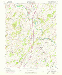
1964 Map of Mount Sidney
USGS Topo · Published 1973About this map
Mount Sidney and Weyers Cave anchor this Shenandoah Valley corridor during a period of infrastructure expansion in the 1960s and early 70s. The landscape is defined by the winding course of the North River and the parallel paths of the Chesapeake Western railroad and Highway 11. While the Shenandoah Valley Airport signals mid-century modernization, the map preserves older layers of settlement through numerous country churches like St Michaels Ch and Melanchthon Chapel. Local genealogy is well-represented by family-named landmarks including Sellers Cem, Landes Cem, and Bells Cem. This topographic study, based on 1960s surveys with 1972 revisions, reveals a transition from traditional agrarian boundaries—marked by visible fence lines—to modern transit hubs and utility sites like the Bridgewater Air Park.
Find a feature on this map
44 named features on this map. Tap any name to fly to it.
Don’t see what you’re looking for? This feature index may not catch every label — zoom into the map to look around manually.
Map Details
Editions of this 1964 Mount Sidney Map
4 editions found
Other maps of this area

1892 · Harrisonburg
USGS Topo · 1:125,000

1894 · Staunton
USGS Topo · 1:125,000

1934 · Waynesboro
USGS Topo · 1:48,000

1939 · Waynesboro
USGS Topo · 1:62,500

1941 · Harrisonburg
USGS Topo · 1:62,500

1943 · Harrisonburg
USGS Topo · 1:62,500

1944 · Parnassus
USGS Topo · 1:62,500

1944 · Staunton
USGS Topo · 1:62,500

1947 · Staunton
USGS Topo · 1:62,500

1947 · Parnassus
USGS Topo · 1:62,500