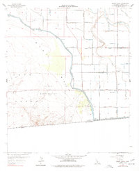
1957 Map of Mount Signal
USGS Topo · Published 1977About this map
The Yuha Naval Reservation dominates the arid landscape of the Imperial Valley along the international border in the mid-1950s. This survey illustrates the stark contrast between the undeveloped desert terrain of Yuha Mesa and West Mesa and the intricate agricultural irrigation network to the east. The complex water system, including the Westside Main Canal and the massive All American Canal, follows the contour of the land just above Sea Level. The small settlement of Mount Signal and the Mt Signal School serve as local landmarks within this irrigated corridor. Natural drainage features like the New River and Pinto Wash cut through the topography, while numerous gaging stations and benchmarks like Vabm 41 indicate the precision of the water management efforts required to sustain the region.
Find a feature on this map
72 named features on this map. Tap any name to fly to it.
Don’t see what you’re looking for? This feature index may not catch every label — zoom into the map to look around manually.
Map Details
Editions of this 1957 Mount Signal Map
4 editions found
Other maps of this area

1915 · El Centro
USGS Topo · 1:125,000

1940 · Brawley
USGS Topo · 1:62,500

1940 · Heber
USGS Topo · 1:62,500

1940 · Plaster City
USGS Topo · 1:62,500

1940 · Coyote Wells
USGS Topo · 1:62,500

1942 · El Centro
USGS Topo · 1:250,000

1943 · Coyote Wells
USGS Topo · 1:62,500

1943 · Heber
USGS Topo · 1:62,500

1943 · Brawley
USGS Topo · 1:62,500

1944 · Plaster City
USGS Topo · 1:62,500