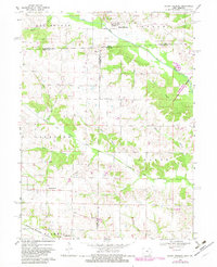
1968 Map of Mount Sterling
USGS Topo · Published 1983About this map
Mount Sterling and the neighboring hills of Vernon and Des Moines townships sit along the northern reaches of this borderland survey. The landscape is defined by the winding course of the Fox River and the Little Fox River, which carve through the terrain before crossing from Iowa into Missouri. Rural life in the late 1960s is evidenced by numerous family-named burial grounds and small community centers, such as Asbury Ch and the settlement at Prospect Grove.
Find a feature on this map
37 named features on this map. Tap any name to fly to it.
Don’t see what you’re looking for? This feature index may not catch every label — zoom into the map to look around manually.
Map Details
Editions of this 1968 Mount Sterling Map
3 editions found
Other maps of this area

1903 · Kahoka
USGS Topo · 1:125,000

1903 · Edina
USGS Topo · 1:125,000

1950 · Medill
USGS Topo · 1:24,000

1951 · Medill
USGS Topo · 1:24,000

1951 · Wyaconda
USGS Topo · 1:24,000

1954 · Centerville
USGS Topo · 1:250,000

1957 · Centerville
USGS Topo · 1:250,000

1958 · Centerville
USGS Topo · 1:250,000

1958 · Burlington
USGS Topo · 1:250,000

1961 · Burlington
USGS Topo · 1:250,000