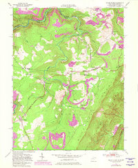
1949 Map of Mount Storm
USGS Topo · Published 1982About this map
Abram Creek carves a deep path through this portion of the Allegheny Front, a landscape where the industrial and the rural exist side-by-side. The presence of purple revision marks reveals the expansion of strip mining operations that occurred decades after the original survey, significantly altering the terrain around Glade Run and south of Hartmansville. Along the northern edge, the Western Maryland railroad follows the winding Potomac River, connecting small coal-era settlements like Emoryville and Sulphur City. Local history is anchored by family and community landmarks such as Schaeffer Cem and the White Hall Sch. The George Washington Highway traverses the central plateau, passing Blake Chapel and the high ridge at Skyline, while the Potomac State Forest preserves the timbered slopes to the northwest near the state line.
Find a feature on this map
40 named features on this map. Tap any name to fly to it.
Don’t see what you’re looking for? This feature index may not catch every label — zoom into the map to look around manually.
Map Details
Editions of this 1949 Mount Storm Map
4 editions found
Other maps of this area

1895 · Piedmont
USGS Topo · 1:125,000

1899 · Oakland
USGS Topo · 1:62,500

1900 · Oakland
USGS Topo · 1:62,500

1916 · Davis
USGS Topo · 1:48,000

1918 · Davis
USGS Topo · 1:62,500

1919 · Elk Garden
USGS Topo · 1:48,000

1919 · Davis
USGS Topo · 1:62,500

1920 · Elk Garden
USGS Topo · 1:48,000

1920 · Davis
USGS Topo · 1:48,000

1921 · Greenland Gap
USGS Topo · 1:62,500