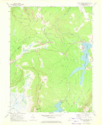
1967 Map of Mount Storm Lake
USGS Topo · Published 1972About this map
Mount Storm Lake and the Stony River dominate this high-elevation landscape on the border of Grant and Tucker counties. During the late 1960s, the region was defined by its industrial activity and rugged topography, where the Western Maryland railroad winds through the hills to serve numerous extractive sites. Traces of the coal industry are everywhere, from the tipple and strip mines near Dobbin Ridge to the gas well on Cherry Run. The natural environment remains prominent, featuring the sweeping Canaan Valley, the marshy Elder Swamp, and the dramatic Allegheny Front. Cultural markers like Camp Seventy-two and the Stony River Dam sit alongside family-named water bodies such as Helmick Run and Morgan Run, reflecting a decade of utility-driven development and traditional Appalachian land use.
Find a feature on this map
38 named features on this map. Tap any name to fly to it.
Don’t see what you’re looking for? This feature index may not catch every label — zoom into the map to look around manually.
Map Details
Editions of this 1967 Mount Storm Lake Map
3 editions found
Other maps of this area

1895 · Piedmont
USGS Topo · 1:125,000

1899 · Oakland
USGS Topo · 1:62,500

1900 · Oakland
USGS Topo · 1:62,500

1916 · Davis
USGS Topo · 1:48,000

1918 · Davis
USGS Topo · 1:62,500

1919 · Elk Garden
USGS Topo · 1:48,000

1919 · Davis
USGS Topo · 1:62,500

1920 · Elk Garden
USGS Topo · 1:48,000

1920 · Davis
USGS Topo · 1:48,000

1921 · Greenland Gap
USGS Topo · 1:62,500