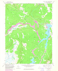
1967 Map of Mount Storm Lake
USGS Topo · Published 1982About this map
Stony River and the high-altitude Mount Storm Lake define this industrial and natural landscape on the eastern edge of the Allegheny Front. The map illustrates the 1960s-era intersection of resource extraction and power generation, anchored by a powerplant, substation, and numerous strip mines that scar the ridges. The complex terrain of Cabin Mountain and Brown Mountain falls away into the headwaters of the Blackwater River and the Little Canaan River, where isolated sites like Camp Seventytwo and Elder Swamp sit far from the main transport corridors. Significant infrastructure including the Western Maryland railroad and a network of pipelines cross the rugged topography of Dobbin Ridge and Timberman Ridge, tracing the paths required to move energy and materials through the Appalachian Highlands.
Find a feature on this map
41 named features on this map. Tap any name to fly to it.
Don’t see what you’re looking for? This feature index may not catch every label — zoom into the map to look around manually.
Map Details
Editions of this 1967 Mount Storm Lake Map
3 editions found
Other maps of this area

1895 · Piedmont
USGS Topo · 1:125,000

1899 · Oakland
USGS Topo · 1:62,500

1900 · Oakland
USGS Topo · 1:62,500

1916 · Davis
USGS Topo · 1:48,000

1918 · Davis
USGS Topo · 1:62,500

1919 · Elk Garden
USGS Topo · 1:48,000

1919 · Davis
USGS Topo · 1:62,500

1920 · Elk Garden
USGS Topo · 1:48,000

1920 · Davis
USGS Topo · 1:48,000

1921 · Greenland Gap
USGS Topo · 1:62,500