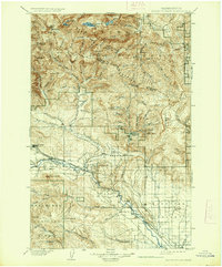
1902 Map of Mount Stuart
USGS Topo · Published 1937About this map
The Northern Pacific R R defines the industrial corridor of the Kittitas Valley, connecting the coal-mining center of Roslyn and the rail hub of Cle Elum toward the regional center of Ellensburg. This early survey, conducted by S.S. Gannett and G.E. Hyde, documents the complex drainage of the Teanaway River and its multiple forks before they join the Yakima system. In the northern reaches, the high alpine landscape of the Wenatchee Mountains is marked by the Snow Creek Glacier and Mt Stuart, while the Wenatchee National Forest boundary delineates the rugged timberlands. Traces of early settlement and mountain transit appear at Meaghersville, Liberty, and Blewett Pass, highlighting the remote outposts that preceded modern highway development. The map also captures specialized lookouts such as Three Brothers Lookout and Taneum Pt Lookout, essential for forest management in this timber-rich era.
Find a feature on this map
93 named features on this map. Tap any name to fly to it.
Don’t see what you’re looking for? This feature index may not catch every label — zoom into the map to look around manually.
Map Details
Editions of this 1902 Mount Stuart Map
5 editions found
Other maps of this area

1897 · Mount Stuart
USGS Topo · 1:125,000

1899 · Ellensburg
USGS Topo · 1:125,000

1901 · Chelan
USGS Topo · 1:125,000

1901 · Ellensburg
USGS Topo · 1:125,000

1901 · Chiwaukum
USGS Topo · 1:125,000

1901 · Snoqualmie Pass
USGS Topo · 1:125,000

1902 · Mount Aix
USGS Topo · 1:125,000

1902 · Skykomish
USGS Topo · 1:125,000

1902 · Mount Stuart
USGS Topo · 1:125,000

1903 · Snoqualmie
USGS Topo · 1:125,000