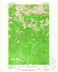
1961 Map of Mount Stuart
USGS Topo · Published 1966About this map
Mount Stuart dominates this high-altitude landscape in the Wenatchee National Forest, serving as the anchor for the granite-peaked Stuart Range. The map reveals a high-alpine wilderness defined by glacial activity, featuring the Upper Enchantment Lakes, Lower Enchantment Lakes, and the permanent ice of Snow Creek Glacier. The distribution of primitive infrastructure reflects a mid-century era of remote resource extraction and early mountain recreation, with the Skookum Mine and Gold Creek Basin pointing toward historical mineral interests.
Find a feature on this map
91 named features on this map. Tap any name to fly to it.
Don’t see what you’re looking for? This feature index may not catch every label — zoom into the map to look around manually.
Map Details
Editions of this 1961 Mount Stuart Map
3 editions found

Other maps of this area

1897 · Mount Stuart
USGS Topo · 1:125,000

1901 · Chiwaukum
USGS Topo · 1:125,000

1901 · Snoqualmie Pass
USGS Topo · 1:125,000

1902 · Skykomish
USGS Topo · 1:125,000

1902 · Mount Stuart
USGS Topo · 1:125,000

1903 · Snoqualmie
USGS Topo · 1:125,000

1904 · Chiwaukum
USGS Topo · 1:125,000

1905 · Skykomish
USGS Topo · 1:125,000

1957 · Wenatchee
USGS Topo · 1:250,000

1958 · Thorp
USGS Topo · 1:62,500