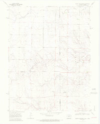
1969 Map of Mount Sunflower
USGS Topo · Published 1972About this map
Mount Sunflower, the highest natural point in Kansas, anchors this High Plains landscape as it appeared in the late 1960s. Located precisely on the Colorado-Kansas state line, the area is defined by the ephemeral drainage patterns of Goose Creek and Turtle Creek. The map documents a sparse, agricultural infrastructure characterized by an extensive network of isolated water Wells and unimproved roads that serve this remote border region. Evidence of early settlement is seen at Hitchcock in the western portion of the quadrangle. The intersection of Cheyenne County, Wallace County, and Kit Carson County creates a complex boundary junction, illustrating how political lines were surveyed across the open prairie. This edition reflects the land before modern center-pivot irrigation significantly altered the surface topography of the western plains.
Find a feature on this map
11 named features on this map. Tap any name to fly to it.
Don’t see what you’re looking for? This feature index may not catch every label — zoom into the map to look around manually.
Map Details
Editions of this 1969 Mount Sunflower Map
2 editions found
Other maps of this area

1892 · Cheyenne Wells
USGS Topo · 1:125,000

1894 · Cheyenne Wells
USGS Topo · 1:125,000

1954 · Limon
USGS Topo · 1:250,000

1954 · Lamar
USGS Topo · 1:250,000

1954 · Goodland
USGS Topo · 1:250,000

1955 · Scott City
USGS Topo · 1:250,000

1956 · Goodland
USGS Topo · 1:250,000

1957 · Limon
USGS Topo · 1:250,000

1957 · Goodland
USGS Topo · 1:250,000

1958 · Limon
USGS Topo · 1:250,000