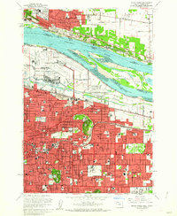
1961 Map of Mount Tabor
USGS Topo · Published 1962About this map
The Columbia River forms a wide natural boundary between Portland and Vancouver in this early 1960s study of the region's expanding infrastructure. The landscape is dominated by volcanic remnants and large-scale transportation hubs, including the Portland International Airport and Portland Air Force Base situated along the Columbia Slough. Residential growth is evident across the east side in neighborhoods like Montavilla, Parkrose, and Powellhurst, where dozens of neighborhood schools and churches such as Holy Child Academy and Warner Pacific College anchor the community.
Find a feature on this map
90 named features on this map. Tap any name to fly to it.
Don’t see what you’re looking for? This feature index may not catch every label — zoom into the map to look around manually.
Map Details
Editions of this 1961 Mount Tabor Map
3 editions found
Other maps of this area

1897 · Portland
USGS Topo · 1:62,500

1905 · Portland
USGS Topo · 1:62,500

1911 · Boring
USGS Topo · 1:48,000

1914 · Boring
USGS Topo · 1:62,500

1914 · Oregon City
USGS Topo · 1:62,500

1916 · Estacada
USGS Topo · 1:125,000

1918 · Troutdale
USGS Topo · 1:62,500

1934 · Troutdale
USGS Topo · 1:48,000

1939 · Oregon City
USGS Topo · 1:62,500

1940 · Boring
USGS Topo · 1:62,500