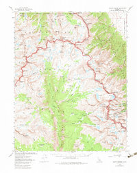
1967 Map of Mount Whitney
USGS Topo · Published 1983About this map
Mount Whitney serves as the focal point of this 1967 survey, where the boundaries of Sequoia National Park, Kings Canyon National Park, and the John Muir Wilderness converge. The landscape is defined by the deep incision of Kern Canyon, which runs south through the heart of the map, flanked by the Chagoopa Plateau and the Kaweah Peaks Ridge. High-altitude water bodies like Tulainyo Lake and Lake Reflection dot the granite basins, providing a clear record of the area's glacial hydrology.
Find a feature on this map
167 named features on this map. Tap any name to fly to it.
Don’t see what you’re looking for? This feature index may not catch every label — zoom into the map to look around manually.
Map Details
Editions of this 1967 Mount Whitney Map
2 editions found
Other maps of this area

1903 · Tehipite
USGS Topo · 1:125,000

1904 · Kaweah
USGS Topo · 1:125,000

1905 · Tehipite
USGS Topo · 1:125,000

1905 · Olancha
USGS Topo · 1:125,000

1907 · Olancha
USGS Topo · 1:125,000

1907 · Mt. Whitney
USGS Topo · 1:125,000

1909 · Kaweah
USGS Topo · 1:125,000

1919 · Mt. Whitney
USGS Topo · 1:125,000

1937 · Mt. Whitney
USGS Topo · 1:125,000

1937 · Kaweah
USGS Topo · 1:125,000