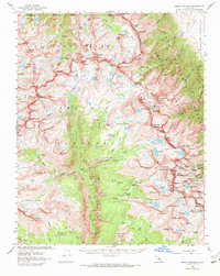
1967 Map of Mount Whitney
USGS Topo · Published 1972About this map
The High Sierra backcountry is documented here during the late 1960s, showing a landscape defined by the intersection of Kings Canyon National Park, Sequoia National Park, and the John Muir Wilderness. The terrain is anchored by the massive bulk of Mount Whitney, with the John Muir Trail and High Sierra Trail providing the primary human corridors through these high-altitude basins. A network of alpine lakes, including the high-elevation Tulainyo Lake and the visually striking Lake Reflection, feed the upper reaches of the Kern River and the Kern-Kaweah River.
Find a feature on this map
163 named features on this map. Tap any name to fly to it.
Don’t see what you’re looking for? This feature index may not catch every label — zoom into the map to look around manually.
Map Details
Editions of this 1967 Mount Whitney Map
2 editions found
Other maps of this area

1903 · Tehipite
USGS Topo · 1:125,000

1904 · Kaweah
USGS Topo · 1:125,000

1905 · Tehipite
USGS Topo · 1:125,000

1905 · Olancha
USGS Topo · 1:125,000

1907 · Olancha
USGS Topo · 1:125,000

1907 · Mt. Whitney
USGS Topo · 1:125,000

1909 · Kaweah
USGS Topo · 1:125,000

1919 · Mt. Whitney
USGS Topo · 1:125,000

1937 · Mt. Whitney
USGS Topo · 1:125,000

1937 · Kaweah
USGS Topo · 1:125,000