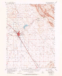
1893 Map of Mountain Home
USGS Topo · Published 1898About this map
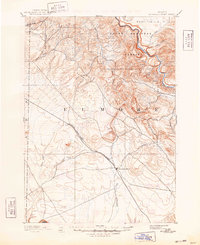
Mountain Home serves as the primary hub in this late nineteenth-century survey of Elmore County, situated along the critical transit corridor of the Oregon Short Line Union Pacific Railroad. This line connects the settlement with the whistle-stop at Cleft to the northwest, following the natural contours of the high desert plain. The landscape is defined by the stark transition between the flat railway corridor and the deeply incised drainage systems to the north, where water flows from the elevated Smith Prairie toward the Boise River. Dozens of seasonal and perennial streams, including Syrup Creek, Long Tom Creek, and Rattlesnake Creek, carve through the plateau. These drainages were essential to early ranchers and settlers in an arid environment, dictating the placement of the early roads and homesteads that began to dot the territory in the years following the 1889 field survey.
Find a feature on this map
19 named features on this map. Tap any name to fly to it.
Don’t see what you’re looking for? This feature index may not catch every label — zoom into the map to look around manually.
Map Details
Editions of this 1893 Mountain Home Map
4 editions found

Historical Maps of Mountain Home Through Time
4 maps found