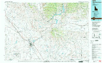
1990 Map of Mountain Home
USGS Topo · Published 1991About this map
Mountain Home Air Force Base and the namesake city of Mountain Home dominate the southwestern reaches of this high desert and mountain landscape. The 1990s-era geography captures the complex relationship between military installations, such as the Idaho National Guard Maneuver and Training Area, and the irrigation-driven agriculture of the Camas Prairie. The Union Pacific railroad corridor serves as a vital artery connecting the smaller settlements like Mayfield and Slaters Flat to the larger regional network.
Find a feature on this map
51 named features on this map. Tap any name to fly to it.
Don’t see what you’re looking for? This feature index may not catch every label — zoom into the map to look around manually.
Map Details
Editions of this 1990 Mountain Home Map
2 editions found
Other maps of this area

1892 · Mountain Home
USGS Topo · 1:125,000

1892 · Boise
USGS Topo · 1:125,000

1892 · Bisuka
USGS Topo · 1:125,000

1892 · Camas Prairie
USGS Topo · 1:125,000

1893 · Mountain Home
USGS Topo · 1:125,000

1893 · Camas Prairie
USGS Topo · 1:125,000

1894 · Bisuka
USGS Topo · 1:125,000

1894 · Idaho Basin
USGS Topo · 1:125,000

1894 · Rocky Bar
USGS Topo · 1:125,000

1897 · Boise
USGS Topo · 1:125,000