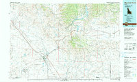
1990 Map of Mountain Home
USGS Topo · Published 1991About this map
The high desert plains of Elmore County meet the rising timber of the Boise National Forest in this 1990 survey. Centered on the growing hub of Mountain Home, the map details a landscape defined by water management and military infrastructure, from the massive Anderson Ranch Reservoir on the South Fork Boise River to the sprawling Mountain Home Air Force Base and its associated Mountain Home Small Arms Range.
Find a feature on this map
80 named features on this map. Tap any name to fly to it.
Don’t see what you’re looking for? This feature index may not catch every label — zoom into the map to look around manually.
Map Details
Editions of this 1990 Mountain Home Map
2 editions found
Other maps of this area

1892 · Mountain Home
USGS Topo · 1:125,000

1892 · Boise
USGS Topo · 1:125,000

1892 · Bisuka
USGS Topo · 1:125,000

1892 · Camas Prairie
USGS Topo · 1:125,000

1893 · Mountain Home
USGS Topo · 1:125,000

1893 · Camas Prairie
USGS Topo · 1:125,000

1894 · Bisuka
USGS Topo · 1:125,000

1894 · Idaho Basin
USGS Topo · 1:125,000

1894 · Rocky Bar
USGS Topo · 1:125,000

1897 · Boise
USGS Topo · 1:125,000