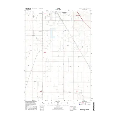
2017 Map of Mountain Home South
USGS Topo · Published 2017About this map
Mountain Home serves as the primary hub on this sheet, illustrating the transition from a traditional residential grid to the sprawling agricultural and aviation-focused landscape of southern Elmore County. The infrastructure is defined by its water management and transportation history, featuring the E Side Canal and W Side Canal alongside significant thoroughfares like Old Hwy 30 and Old Grandview Rd. The southern portion of the quadrangle opens into the broad expanses of Slade Flat and Clover Hollow, where the landscape is largely shaped by rural section lines and irrigation paths. Local aviation is represented by Coyote Run Airport, situated just south of the main settlement. This 2017 survey provides a clear view of how the modern high-desert community maintains its connection to earlier transportation corridors and large-scale land divisions.
Find a feature on this map
62 named features on this map. Tap any name to fly to it.
Don’t see what you’re looking for? This feature index may not catch every label — zoom into the map to look around manually.
Map Details
Editions of this 2017 Mountain Home South Map
This is the sole edition of this map. No revisions or reprints were ever made.
Other maps of this area

1892 · Mountain Home
USGS Topo · 1:125,000

1893 · Mountain Home
USGS Topo · 1:125,000

1947 · Bruneau
USGS Topo · 1:62,500

1947 · Indian Cove
USGS Topo · 1:24,000

1947 · Sand Dunes
USGS Topo · 1:24,000

1947 · Bruneau
USGS Topo · 1:24,000

1948 · Sand Dunes
USGS Topo · 1:24,000

1948 · Indian Cove
USGS Topo · 1:24,000
1948 · Bruneau
USGS Topo · 1:24,000

1948 · Indian Cove
USGS Topo · 1:62,500