1993 Map of Mountain Island Lake
USGS Topo · Published 1996About this map
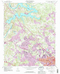
Mountain Island Lake and the Catawba River serve as the focal points for this 1990s-era map, capturing the intersection of hydroelectric development and suburban expansion on the outskirts of Charlotte. The presence of the Powerplant near the Duke Power Village reflects the industrial infrastructure that defined the region's energy production, while the purple revision layers illustrate the rapid transition of the landscape into residential areas like Shuffletown and Oakdale.
Find a feature on this map
54 named features on this map. Tap any name to fly to it.
Don’t see what you’re looking for? This feature index may not catch every label — zoom into the map to look around manually.
Map Details
Editions of this 1993 Mountain Island Lake Map
This is the sole edition of this map. No revisions or reprints were ever made.
Other maps of this area

1905 · Charlotte
USGS Topo · 1:48,000

1907 · Charlotte
USGS Topo · 1:62,500

1914 · Gastonia
USGS Topo · 1:48,000

1916 · Gastonia
USGS Topo · 1:62,500

1941 · Charlotte
USGS Topo · 1:125,000

1942 · Charlotte
USGS Topo · 1:125,000

1947 · Clover
USGS Topo · 1:62,500

1948 · Paw Creek
USGS Topo · 1:24,000

1948 · Derita
USGS Topo · 1:24,000

1948 · Charlotte East
USGS Topo · 1:24,000