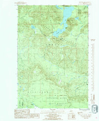
1985 Map of Mountain Lake
USGS Topo · Published 1985About this map
The Huron Mountains dominate this 1980s landscape, characterized by a series of prominent peaks and high-elevation lakes along the border of Baraga and Marquette counties. Dramatic elevation changes are centered around Mountain Lake, which features Lumberman Bay and Dudley Point, while other summits like Mount Ida, Mount Benison, and Mummy Mountain punctuate the northern terrain. The intricate hydrology of the region is evident in the network of streams feeding the Salmon Trout River and the West Branch Trout River, which flow through the southern portion of the sheet near Dodge City. The southern boundary is defined by the Escanaba River State Forest, where the Fifth Correction Line marks a significant survey transition. This map preserves a view of the Upper Peninsula's interior wilderness before modern developments, showing the remote character of Cliff Lake and the various ponds and creeks that drain this high country.
Find a feature on this map
36 named features on this map. Tap any name to fly to it.
Don’t see what you’re looking for? This feature index may not catch every label — zoom into the map to look around manually.
Map Details
Editions of this 1985 Mountain Lake Map
This is the sole edition of this map. No revisions or reprints were ever made.
Other maps of this area

1954 · Huron Mountain
USGS Topo · 1:62,500

1954 · Skanee
USGS Topo · 1:62,500

1955 · Champion
USGS Topo · 1:62,500

1956 · Michigamme
USGS Topo · 1:62,500

1958 · Marquette
USGS Topo · 1:250,000

1958 · Iron River
USGS Topo · 1:250,000

1960 · Iron River
USGS Topo · 1:250,000

1960 · Marquette
USGS Topo · 1:250,000

1961 · Marquette
USGS Topo · 1:250,000

1961 · Iron River
USGS Topo · 1:250,000