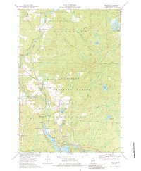
1973 Map of Mountain
USGS Topo · Published 1984About this map
The Chicago and North Western Railway cuts through the center of this Oconto County landscape, passing directly through the community of Mountain. This early 1970s record shows a region defined by its timber and water resources within the Nicolet National Forest. To the south, recreational and residential development clusters around Chute Pond and Midget Lake, supported by facilities like St Michael Chapel and various campgrounds. The presence of the Mountain Lookout Tower on Silver Hill and the Bowman Airport further north highlights the management and accessibility of these forest lands.
Find a feature on this map
64 named features on this map. Tap any name to fly to it.
Don’t see what you’re looking for? This feature index may not catch every label — zoom into the map to look around manually.
Map Details
Editions of this 1973 Mountain Map
3 editions found
Other maps of this area

1940 · Thunder Mtn.
USGS Topo · 1:48,000

1942 · Breed
USGS Topo · 1:48,000

1942 · Wabeno
USGS Topo · 1:48,000

1950 · Wabeno
USGS Topo · 1:48,000

1951 · Wabeno
USGS Topo · 1:48,000

1951 · Thunder Mountain
USGS Topo · 1:48,000

1952 · Langlade
USGS Topo · 1:48,000

1952 · Mountain
USGS Topo · 1:48,000

1954 · Iron Mountain
USGS Topo · 1:250,000

1959 · Iron Mountain
USGS Topo · 1:250,000