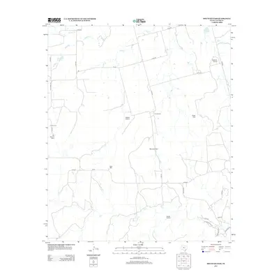
2012 Map of Mountain Pass
USGS Topo · Published 2012About this map
Mountain Pass anchors this portion of Taylor County, where the Texas landscape transitions from the higher elevations of Riney Peak and Bald Mtn into deep drainages and canyons. The presence of Butterfield Trail Rd in the southern portion of the quadrangle suggests the enduring path of historic transit corridors through the region. This 2012 survey illustrates a land primarily defined by ranching and water management, featuring names like Rhodes Ranch and small impoundments such as the Billy Doan Reservoir and Hugh Lilly Lake. The terrain is deeply etched by Mulberry Canyon and Horse Hollow, while the waters of Elm Cr and Mulberry Cr provide the primary drainage. The settlement pattern is sparse, represented by Butman Camp and the namesake Mountain Pass, reflecting the rural character of west-central Texas.
Find a feature on this map
37 named features on this map. Tap any name to fly to it.
Don’t see what you’re looking for? This feature index may not catch every label — zoom into the map to look around manually.
Map Details
Editions of this 2012 Mountain Pass Map
This is the sole edition of this map. No revisions or reprints were ever made.
Other maps of this area

1890 · Abilene
USGS Topo · 1:125,000

1892 · Abilene
USGS Topo · 1:125,000

1893 · Sweetwater
USGS Topo · 1:125,000

1954 · Big Spring
USGS Topo · 1:250,000

1954 · Abilene
USGS Topo · 1:250,000

1957 · Merkel
USGS Topo · 1:62,500

1957 · Buffalo Gap
USGS Topo · 1:62,500

1958 · Big Spring
USGS Topo · 1:250,000

1958 · Abilene
USGS Topo · 1:250,000
1967 · Shep
USGS Topo · 1:24,000