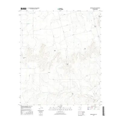
2016 Map of Mountain Pass
USGS Topo · Published 2016About this map
Mountain Pass marks a significant topographic gap in the western Taylor County landscape, where the terrain transitions through a series of named elevations and deep draws. High points like Castle Peak and Riney Peak overlook a network of seasonal watercourses and local ranch roads, while Bald Mtn stands as a prominent central landmark. The drainage patterns of Elm Cr and Mulberry Cr have carved distinct landforms such as Mulberry Canyon and Horse Hollow, shaping the regional movement of people and livestock for generations.
Find a feature on this map
33 named features on this map. Tap any name to fly to it.
Don’t see what you’re looking for? This feature index may not catch every label — zoom into the map to look around manually.
Map Details
Editions of this 2016 Mountain Pass Map
This is the sole edition of this map. No revisions or reprints were ever made.
Other maps of this area

1890 · Abilene
USGS Topo · 1:125,000

1892 · Abilene
USGS Topo · 1:125,000

1893 · Sweetwater
USGS Topo · 1:125,000

1954 · Big Spring
USGS Topo · 1:250,000

1954 · Abilene
USGS Topo · 1:250,000

1957 · Merkel
USGS Topo · 1:62,500

1957 · Buffalo Gap
USGS Topo · 1:62,500

1958 · Big Spring
USGS Topo · 1:250,000

1958 · Abilene
USGS Topo · 1:250,000
1967 · Shep
USGS Topo · 1:24,000