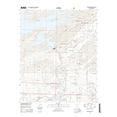
2014 Map of Mountain Pine
USGS Topo · Published 2014About this map
Lake Ouachita and Lake Hamilton dominate the terrain of this Garland County region, separated by the prominent ridge of Blakely Mtn. The town of Mountain Pine sits at the base of the mountains near the banks of Glazypeau Cr, serving as a central hub for the surrounding timberlands of the Ouachita National Forest. The map reveals a dense network of forest roads with evocative names like High Lead Rd, Brushfire Rd, and Old Tram Rd, reflecting the area's deep-rooted logging history.
Find a feature on this map
162 named features on this map. Tap any name to fly to it.
Don’t see what you’re looking for? This feature index may not catch every label — zoom into the map to look around manually.
Map Details
Editions of this 2014 Mountain Pine Map
This is the sole edition of this map. No revisions or reprints were ever made.
Other maps of this area

1890 · Hot Springs
USGS Topo · 1:125,000

1894 · Hot Springs
USGS Topo · 1:125,000

1955 · Little Rock
USGS Topo · 1:250,000

1956 · Little Rock
USGS Topo · 1:250,000

1960 · Little Rock
USGS Topo · 1:250,000

1962 · Crystal Springs
USGS Topo · 1:24,000

1962 · Avant
USGS Topo · 1:24,000

1964 · Little Rock
USGS Topo · 1:250,000

1966 · Pearcy
USGS Topo · 1:24,000
1966 · Hot Springs North
USGS Topo · 1:24,000