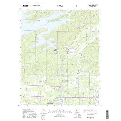
2020 Map of Mountain Pine
USGS Topo · Published 2020About this map
Lake Ouachita dominates the northern reaches of this landscape, its complex shoreline defined by the flooded valleys of the Ouachita National Forest. The settlement of Mountain Pine serves as a central hub for the area's timber and recreational activity, positioned between the waters of the lake and the flowing Glazypeau Creek. The topography is shaped by substantial ridges like Blakely Mtn and Brady Mtn, which frame the transition from the high forest into the lower valley floor near Piney and Royal.
Find a feature on this map
140 named features on this map. Tap any name to fly to it.
Don’t see what you’re looking for? This feature index may not catch every label — zoom into the map to look around manually.
Map Details
Editions of this 2020 Mountain Pine Map
This is the sole edition of this map. No revisions or reprints were ever made.
Other maps of this area

1890 · Hot Springs
USGS Topo · 1:125,000

1894 · Hot Springs
USGS Topo · 1:125,000

1955 · Little Rock
USGS Topo · 1:250,000

1956 · Little Rock
USGS Topo · 1:250,000

1960 · Little Rock
USGS Topo · 1:250,000

1962 · Crystal Springs
USGS Topo · 1:24,000

1962 · Avant
USGS Topo · 1:24,000

1964 · Little Rock
USGS Topo · 1:250,000

1966 · Pearcy
USGS Topo · 1:24,000
1966 · Hot Springs North
USGS Topo · 1:24,000