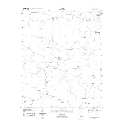
2011 Map of Mountain View SW
USGS Topo · Published 2011About this map
Mountain View sits at the northern edge of this Ozark plateau landscape, where the topography is defined by a dense network of hollows and ridges. The settlement pattern follows the high ground and narrow valley floors, with communities like East Richwoods, West Richwoods, and Sunny Land connected by a web of county roads. The terrain is marked by significant elevations such as Finch Mountain and Indian Knob, which overlook the winding paths of Tomahawk Creek and Lick Fork. Genealogists will find notable burial sites recorded here, including Fredonia Cemetery near the center of the quadrangle and Finch Cemetery further south. Numerous family-named landmarks like Brown Camp Hollow, McGee Hollow, and Wade Hill suggest the deep roots of local homesteads. The map illustrates a rural area where the natural drainage of features like Cave Spring Branch and Turkey Creek has long dictated the placement of homesteads and thoroughfares.
Find a feature on this map
105 named features on this map. Tap any name to fly to it.
Don’t see what you’re looking for? This feature index may not catch every label — zoom into the map to look around manually.
Map Details
Editions of this 2011 Mountain View SW Map
This is the sole edition of this map. No revisions or reprints were ever made.
Other maps of this area

1892 · Mountain View
USGS Topo · 1:125,000

1894 · Mountain View
USGS Topo · 1:125,000

1956 · Russellville
USGS Topo · 1:250,000

1964 · Russellville
USGS Topo · 1:250,000
1964 · Sylamore
USGS Topo · 1:24,000

1969 · Mountain View SW
USGS Topo · 1:24,000
1969 · Fox
USGS Topo · 1:24,000
1969 · Mountain View
USGS Topo · 1:24,000
1972 · Onia
USGS Topo · 1:24,000
1972 · Fiftysix
USGS Topo · 1:24,000